BIM for Earthquake Resilience: How Structural BIM Is Transforming Seismic-Safe Construction in the U.S

Earthquakes may be unpredictable, but the resilience of urban infrastructure can still be strengthened through informed design and planning. Across the United States, regions with high seismic activity are rapidly adopting Structural Building Information Modeling (Structural BIM) to design earthquake-resilient, safer, and smarter buildings. By integrating 3D modeling, clash detection, real-time simulations, and code-based analytics, BIM empowers engineers, architects, and planners to build structures that withstand earthquakes while reducing project risks, costs, and timelines.
Traditional construction often pushes seismic considerations to late project stages, creating costly risks. BIM changes this by placing structural performance and seismic planning at the core of the design phase.
With Structural BIM, cities and project teams can:
- Detect structural vulnerabilities early in design.
- Conduct advanced stress, load, and seismic response simulations.
- Integrate architecture, MEP, and structural systems seamlessly.
- Plan targeted retrofitting for aging or historic buildings.
- Reduce construction errors, delays, and rework.
This proactive digital approach ensures infrastructure is resilient long before construction begins.
Structural BIM is a data-rich 3D digital model representing core structural elements such as foundations, columns, beams, load-bearing walls, and slabs. Unlike traditional drawings, BIM offers an intelligent, coordinated model that engineers can analyze, simulate, and validate for seismic performance.
Key Features of Structural BIM
- Detailed 3D modeling of all structural components
- Automated clash detection and interdisciplinary coordination
- Seismic load, stress, and vibration simulations
- Integration with architectural and MEP designs
- Accurate BOQs, cost estimation, and material optimization
- Enhanced compliance with local and international seismic codes
Structural BIM ensures not only safety and code alignment but also efficiency, sustainability, and operational readiness.
- Enables early identification of structural weaknesses and seismic risks
- Supports advanced simulation of earthquakes, aftershocks, and structural responses
- Improves accuracy in reinforcement detailing and load path design
- Ensures continuous compliance with evolving seismic safety codes
- Reduces project delays and costly construction rework
- Enhances urban planning through scenario-based disaster modeling
- Facilitates rapid assessment and restoration after an earthquake
- Provides lifecycle resilience planning for long-term infrastructure stability
- Helps governments and agencies prioritize retrofitting of critical structures
- Strengthens public safety through data-driven decision-making
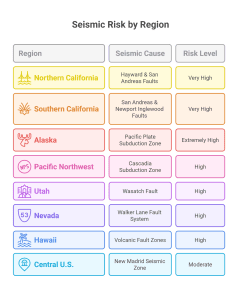
These areas face frequent tremors, aging infrastructure, and dense populations making digital resilience critical.
The U.S. Geological Survey (USGS) identifies several regions at high seismic risk. These cities are increasingly leveraging BIM to reinforce safety, improve building codes, and guide retrofitting programs.
Major BIM-Adopting Seismic Cities
- Los Angeles, California – Near the San Andreas Fault; BIM is central to new builds and large-scale retrofits.
- San Francisco, California – Pioneer in seismic regulations; BIM is used for both modern towers and historic preservation.
- Seattle, Washington – Growing seismic awareness drives BIM-based structural optimization and material innovation.
- Anchorage, Alaska – One of the most earthquake-prone U.S. cities; BIM enhances critical infrastructure resilience.
- Salt Lake City, Utah – Located near the Wasatch Fault; BIM supports efficient retrofitting of public buildings and hospitals.
These cities face challenges such as aging infrastructure, dense populations, and frequent tremors making BIM-powered resilience essential.

Seattle’s expanding skyline and proximity to major fault lines make seismic resilience a top priority. BIM is being used to:
- Simulate structural movement during mild to severe tremors
- Integrate seismic dampers, flexible joints, and energy-dissipation systems
- Validate compliance with Washington state’s stringent seismic codes
- Evaluate the real-time behavior of high-rise structures under earthquake conditions
With BIM-driven engineering insights, Seattle is building smarter and safer structures for the future.
BIM goes beyond visualization it acts as a complete resilience ecosystem, enabling earthquake-resistant design, smarter construction planning, and faster post-disaster recovery.
- Seismic-Resilient Design
- Models shear walls, bracing systems, base isolators, and dampers in 3D
- Simulates load distribution, structural drift, and vibration behavior
- Ensures stronger, safer designs before construction begins
- Built-In Code Compliance
- Automatic checks against ASCE 7, IS 1893, Eurocode 8, and other seismic guidelines
- Identifies structural non-compliance early
- Reduces approval delays and redesigns
- Reinforcement Accuracy
- Prevents clashes in rebar, beams, and column detailing
- Ensures critical seismic zones have proper reinforcement
- Minimizes structural risks and on-site rework
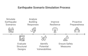
- Scenario-Based Earthquake Testing
- Virtual testing for magnitudes 6.0 to 8.0
- Evaluates primary shocks, aftershocks, and multi-hazard scenarios
- Enhances preparedness and reliability
- Optimized Materials & Earthquake-Safe Design
- Models various steel, concrete, and composite systems
- Simulates base-isolation and damping system impacts
- Optimizes material usage for maximum seismic resilience
Structural BIM accelerates recovery efforts after seismic events.
How BIM Supports Post-Quake Recovery
- Captures detailed as-built damage using laser scanning and UAV surveys
- Converts damage data into accurate 3D BIM models
- Enables targeted retrofitting instead of costly full reconstruction
- Reduces downtime and speeds up rehabilitation of buildings and infrastructure
Saving Costs with BIM in Earthquake Zones
BIM delivers long-term cost benefits for both governments and developers:
- Eliminates design conflicts early, reducing expensive corrections
- Optimizes material use for seismic stability
- Provides accurate cost forecasting using 5D BIM
- Minimizes delays, disruptions, and downtime
- Reduces post-earthquake restoration expenses by enabling precision repairs
Investment in BIM today prevents multi-million-dollar losses after an earthquake.
Clove Technologies brings together digital engineering, Structural BIM, and geospatial intelligence to strengthen U.S. cities against seismic threats.
Our Comprehensive BIM Solutions for Earthquake Safety
- Structural BIM modeling with seismic analysis focus
- Scan-to-BIM for post-quake assessment and documentation
- UAV-based structural inspection and damage mapping
- Retrofitting and restoration planning
- 5D BIM for accurate budgeting and cost control
From Los Angeles to Seattle and Anchorage to Salt Lake City, Clove Technologies is helping cities build infrastructure that can withstand, adapt, and recover from seismic events.
- How does BIM help buildings resist earthquakes?
BIM enhances earthquake resistance by enabling detailed 3D structural modeling, seismic load simulations, and reinforcement accuracy. Engineers can test multiple earthquake scenarios, optimize material use, and ensure code compliance before construction. This proactive digital approach minimizes structural weaknesses, reduces design errors, and strengthens a building’s ability to withstand seismic forces.
- Which U.S. cities face the highest earthquake risks?
The highest-risk U.S. cities include Los Angeles, San Francisco, Seattle, Anchorage, and Salt Lake City, each located near major seismic fault lines such as the San Andreas, Cascadia, and Wasatch systems. These cities adopt BIM-driven design to improve seismic resilience, strengthen aging infrastructure, and support advanced retrofitting programs for public safety.
- What BIM services support seismic design and analysis?
Key BIM services for seismic planning include Structural BIM modeling, clash detection, rebar detailing, 4D scheduling, 5D cost modeling, and high-precision seismic simulations. These tools help assess load behavior, identify structural conflicts, enhance coordination, and verify compliance with seismic codes, enabling robust, earthquake-ready designs across both new construction and retrofitting projects.
- Why is BIM important for regions with high seismic activity?
BIM is crucial in high-risk seismic regions because it improves structural safety through accurate modeling, early detection of vulnerabilities, and automated code compliance checks. It enables scenario-based earthquake testing, optimized reinforcement design, and coordinated planning, helping reduce failures, construction delays, and long-term disaster recovery costs while enhancing urban resilience.
- How does Scan-to-BIM help strengthen existing buildings against earthquakes?
Scan-to-BIM captures precise as-built structural conditions using laser scanning and UAV imaging, converting them into accurate 3D models. Engineers can identify cracks, deformation, and weak zones, enabling targeted retrofitting rather than full reconstruction. This improves seismic resilience, reduces costs, and supports faster restoration of older or damaged buildings in earthquake-prone areas.
Discover more of our innovative blogs

Choosing the Right MEPF BIM Partner: Why Clove Technologies Stands Out

How Scan to BIM Streamlines Construction Planning and Coordination
Reduce Project Timelines by 40% with our Advanced Scan to CAD Services

Everything You Need to Know About Pipe Spool Fabrication
Let's Talk
Let’s discuss your requirements and see how our expertise can help on your next project.