What did we seek to achieve ?
Accurate measurement, visualization and modeling of the interior spaces of Ravindra Natya Mandir.
PROJECT INFORMATION:
| Client: | Owners |
| SERVICE: | Drone Survey, 3D Laser Scanning, Scan to CAD, Scan to BIM |
| INDUSTRY: | Commercial |
Software Used:
How did we achieve it ?
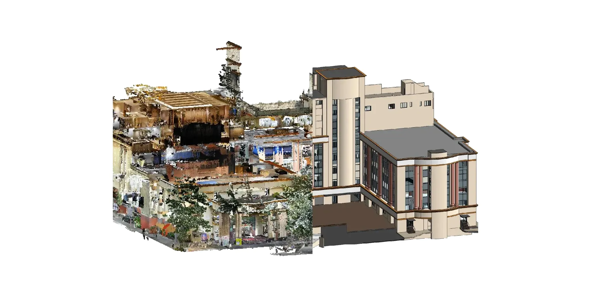
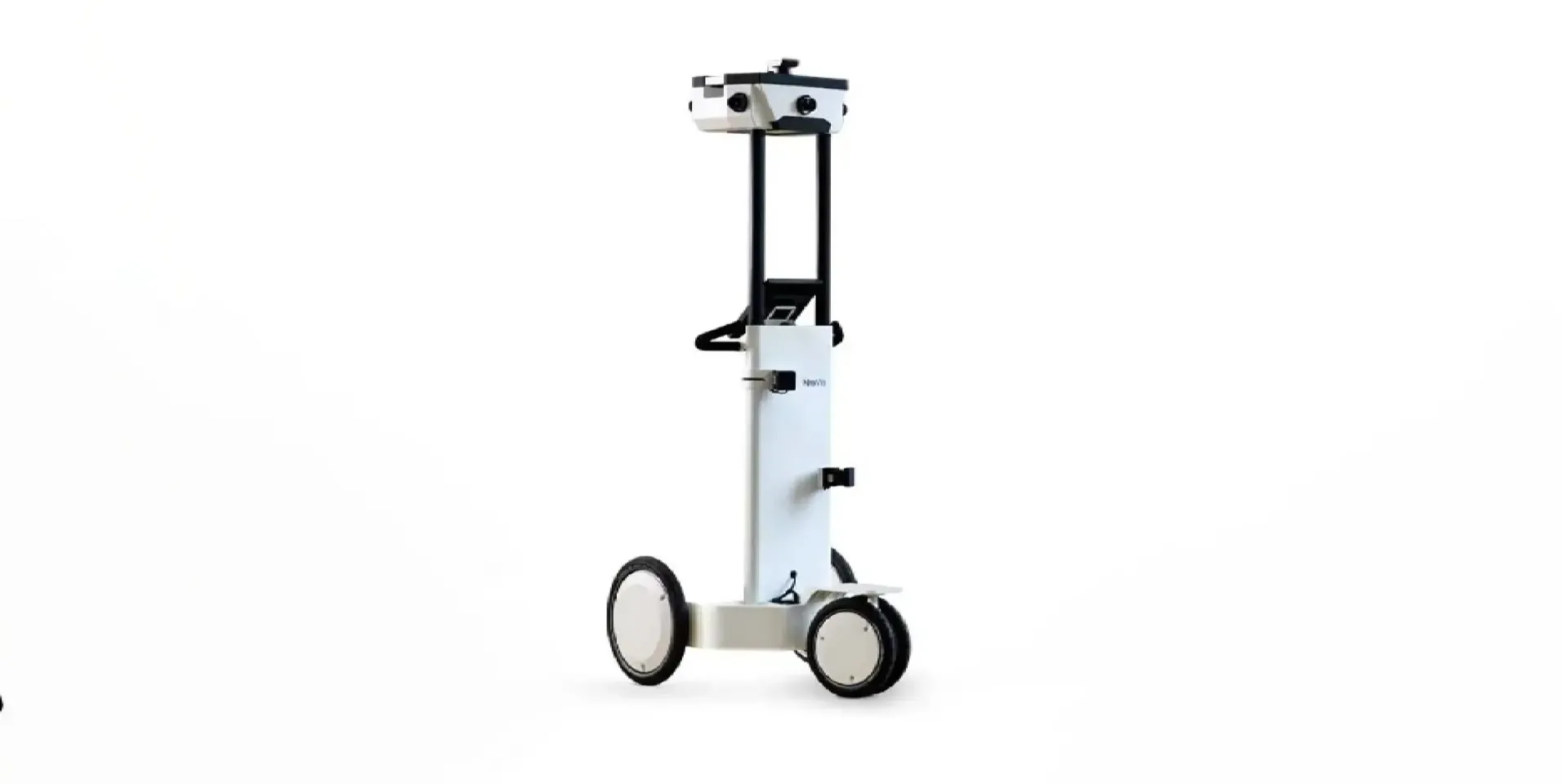
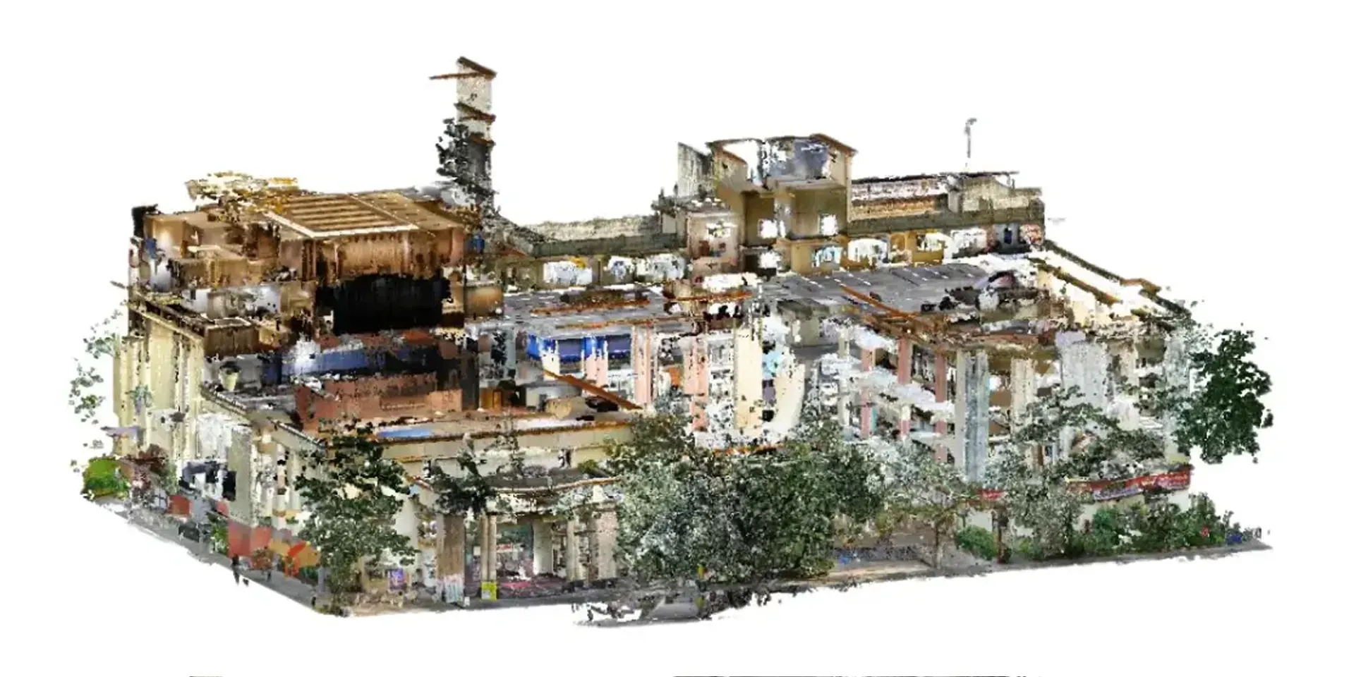
To meet the client’s requirements, we employed NavVis, an advanced scanning equipment and UAV data, we aligned and processed raw data, segmenting into external and internal areas for precise modeling.Data provided by NavVis has precise measurements and clear visualization of structural damages. Laser scans were performed using NavVis, generating detailed point cloud data. The data was then transformed into 2D or 3D representations based on the client’s specifications.
NavVis facilitated data collection in various views, including point cloud data, panoramic images and map views. We aligned the data floor-wise to accurately represent each level of the eight-storied building.
Ravindra Natya Mandir, a prominent cultural venue, is renowned for hosting theater performances and cultural events. With an increasing need for renovation and effective space management, the client aimed to create a comprehensive digital twin of the entire facility. Clove Technologies was commissioned to execute this task, combining high-resolution 3D scanning and Building Information Modeling.
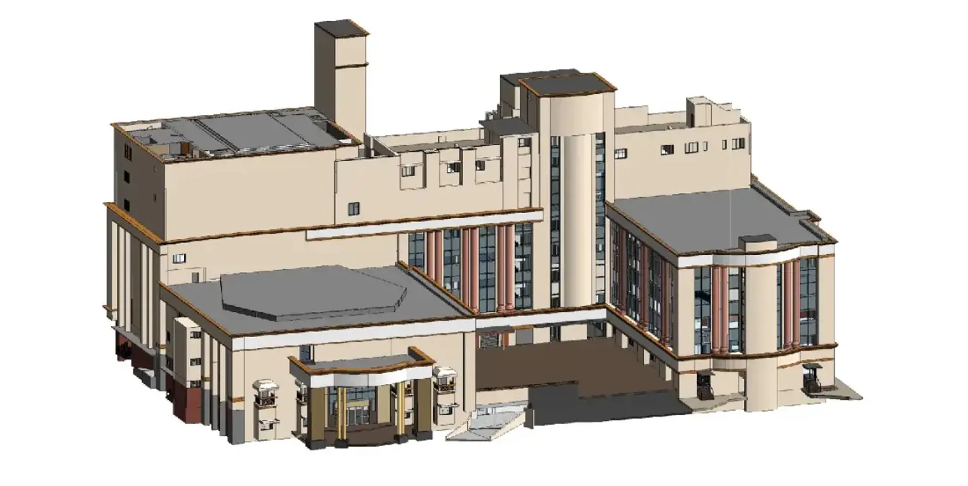
Modeling was performed at a Level of Detail (LOD) of 300, ensuring high accuracy. The models included textures and furniture, such as auditorium chairs, for a realistic portrayal of the spaces.
Project Objectives
- Develop an accurate 3D representation of both the interior and exterior.
- Assess structural integrity and support retrofitting efforts.
- Enable immersive virtual navigation for stakeholders.
- Provide visual data to improve facility planning and asset tracking.
Our Approach
1. Data Acquisition
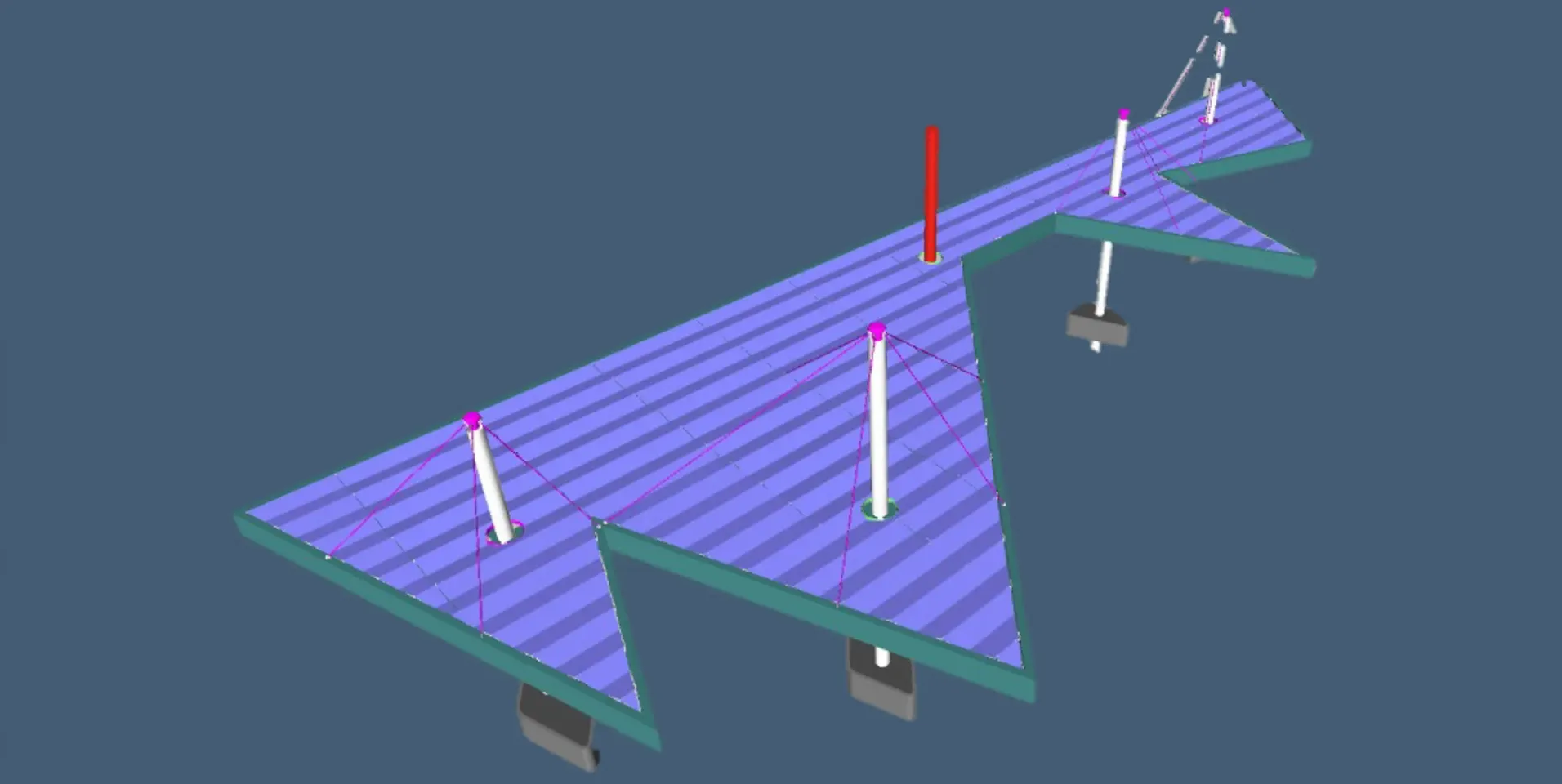
Using the NavVis M6 Indoor Mapping System, our team captured panoramic imagery and laser scan point cloud data across all eight floors. Simultaneously, UAV drones captured aerial photogrammetry to cover roof structures and surroundings.
2. Floor-Wise Alignment & Processing
The collected datasets were aligned floor-by-floor to ensure structural consistency. Careful segmentation was performed between internal and external environments. This step addressed core areas, staircases, fixed elements, and building elevations.
3. BIM Modeling
With data refined, our BIM team used Autodesk Revit to create LOD 300 models of the interior. These models incorporated not just walls and structural elements, but also furnishings like auditorium chairs and stage equipment, creating a realistic and functional 3D replica.
CHALLENGES
- UAVs struggled with precise corner detection due to limitations in Ground Control Point (GCP) placement.
- NavVis had accuracy issues at higher elevation points.
- Data alignment between UAV and NavVis scans required manual corrections to eliminate geolocation discrepancies.
Despite these hurdles, the combined datasets were successfully aligned, ensuring a high-accuracy digital twin.
Final Deliverables
- Fully aligned and georeferenced 3D BIM model (LOD 300)
- Floor-by-floor panoramic visualization
- Aerial ortho imagery
- Accurate point cloud data for structural reference
- Digital floor plans and asset maps
Outcomes & Impact
- Improved Retrofitting Plans: Enabled engineers to identify structurally compromised areas for intervention.
- Immersive Visualization: Stakeholders can now access a virtual walkthrough of the facility.
- Efficient Space Management: Asset layout and facility usage can now be monitored and optimized digitally.
- Long-Term Preservation: A digital archive of Ravindra Natya Mandir is now in place for future use and planning.
The Ravindra Natya Mandir project underscores the power of integrating NavVis indoor scanning, UAV photogrammetry, and BIM modeling to support heritage preservation and modernization. Clove Technologies delivered a rich digital twin that not only supports current needs but also serves as a foundation for future enhancements.
Want to digitize your heritage building or commercial facility? Contact Us today to discover how our scanning and BIM solutions can transform your site