The AEC industry is experiencing a major shift. Complex projects, tighter deadlines, and the demand for greater accuracy have pushed traditional workflows to their limits. In this environment new technologies aren’t just helpful, they are essential.
Our journey with NavVis reality capture technology began with a simple belief: that the future of AEC lies in accurate data, seamless collaboration, and digital first execution. As early adopters we weren’t just looking for incremental improvements we wanted a breakthrough that would redefine how we deliver projects.
This decision to embrace NavVis has transformed the way we approach scan-to-BIM, digital twins, indoor mapping, and facility management. What started as an investment quickly became a turning point in how we think, plan, and build.
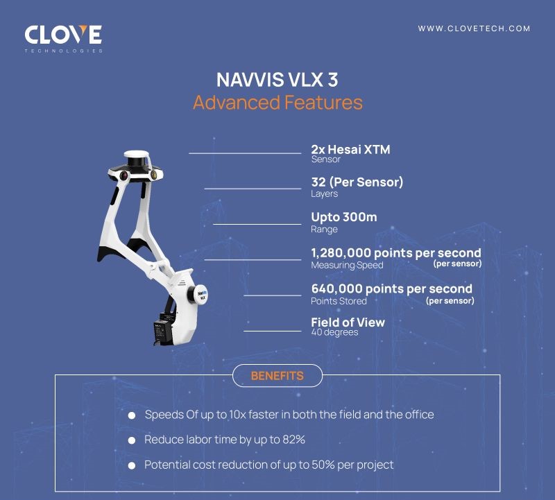
NavVis is a leading reality capture and digital twin technology provider that develops advanced mobile mapping systems and software. Using SLAM (Simultaneous Localization and Mapping) and LiDAR scanning, NavVis devices such as the NavVis VLX and M6/MLX capture highly accurate 3D point clouds, panoramic imagery, and geospatial data of complex indoor and outdoor environments.
This technology enables professionals in theAEC(Architecture, Engineering, and Construction) industry to create digital twins, BIM models, and as-built documentation, driving accuracy, efficiency, and collaboration across all project phases.
AEC firms today face several recurring challenges:
- Inaccurate documentation leading to costly rework.
- Project delays caused by slow surveying and modeling methods.
- Poor collaboration across stakeholders due to outdated information.
- Difficulty in maintaining as-built data for facility management and operations.
When we first implemented NavVis technology, our goal was clear: deliver more value to clients by bridging the gap between physical spaces and digital models. Being early adopters meant we had to experiment, innovate, and integrate NavVis into a variety of use cases, including:
- Scan-to-BIM for large-scale projects – delivering accurate 3D BIM models faster than ever.
- Facility management integration – creating digital twins that simplify asset tracking and maintenance.
- Construction progress monitoring – capturing frequent, detailed site scans to keep stakeholders aligned.
- Indoor mapping for complex environments – ensuring accurate navigation and documentation of large facilities.
This hands-on experience allowed us to set industry benchmarks and demonstrate how NavVis workflows reduce errors, shorten project timelines, and ultimately save costs.
Explore one of our flagship project here: NavVis Utilization in Healthcare
Becoming an early adopter of NavVis reality capture technology gave us more than just a competitive advantage; it taught us valuable lessons about change, integration, and innovation. Some of the biggest takeaways from our journey include:
- Adoption requires cultural change: Introducing NavVis was not just a technical shift but also a mindset shift. Teams had to adapt from working with 2D drawings to thinking in immersive 3D environments.
- Client education is crucial: Many clients were amazed at the data NavVis could provide but needed guidance on how to use it effectively in design, construction, and operations.
- Integration unlocks real value: NavVis becomes most powerful when integrated with BIM platforms, facility management software, and project collaboration tools, making data actionable rather than just impressive.
- Speed creates new opportunities: Capturing and delivering data faster than ever meant we could take on larger, more complex projects without stretching resources.
These lessons continue to shape how we deploy NavVis today and how we design workflows for future projects.
1. How accurate is NavVis scanning technology?
NavVis systems deliver survey-grade accuracy with centimeter-level precision, making the data reliable for scan-to-BIM, digital twins, and construction verification workflows.
2. What are the cost-saving benefits of NavVis?
By reducing errors, minimizing rework, and accelerating project documentation, NavVis helps AEC firms cut costs while delivering higher-quality outcomes for clients.
3. Is NavVis only for large-scale projects?
No. While NavVis shines in large and complex environments, it’s equally effective for smaller projects, especially when speed and accuracy are critical.
4. How does NavVis support facility management after construction?
NavVis enables digital twin creation, allowing facility managers to track assets, monitor maintenance needs, and update records in real time all linked to accurate as-built data.
5. Where can NavVis be used in the AEC industry?
NavVis is used for:
- Scan-to-BIM for design and coordination.
- Construction progress monitoring.
- Facility management and operations.
- Indoor mapping of complex environments.
- Creating digital twins for asset lifecycle management.
At Clovetech, we’ve seen how NavVis reality capture technology redefines the way AEC projects are delivered from Scan-to-BIM and digital twins to facility management and progress monitoring.
If you’re ready to eliminate costly rework, accelerate timelines, and empower your team with accurate, immersive data, NavVis is the breakthrough you’ve been waiting for.
Discover how Clovetech can bring NavVis to your next project.
Contact Us Today
Discover more of our innovative blogs
Mechanical BIM Modeling Workflow for MEP Coordination

Scan to BIM Services in Texas for Commercial Renovation Projects

Step-by-Step Guide to Paper to CAD Conversion

Top MEP BIM Services in the USA
Let's Talk
Let’s discuss your requirements and see how our expertise can help on your next project.