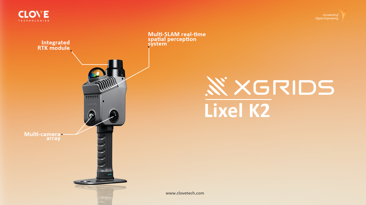
Clove Technologies launches Lixel K2 by XGRIDS to accelerate reality capture, spatial data collection, and digital engineering workflows.
The built environment is becoming increasingly digital. From buildings and infrastructure to industrial facilities and complex engineering environments, organizations need accurate digital representations of physical spaces to design, build, inspect, operate, and maintain assets more effectively.
But before a physical environment can become a digital model or digital twin, there is one critical step: capturing reality.
That is where Lixel K2 by XGRIDS comes in.
As a Global Partner of XGRIDS, Clove Technologies is bringing Lixel K2 into its reality capture and digital engineering capabilities, enabling a faster path from physical environments to high-quality spatial data, point clouds, 3D models, and digital workflows.
Lixel K2 is a lightweight spatial scanning system designed to capture real-world environments quickly while generating detailed spatial data.
Powered by a Multi-SLAM real-time spatial perception system, an integrated RTK module, and a multi-camera array, Lixel K2 combines spatial positioning, environmental capture, and real-time processing into a single field-ready solution.
Rather than treating reality capture as simply a surveying exercise, Lixel K2 enables teams to create a digital representation of the environment that can feed into multiple downstream applications.
From:
Physical Space → Spatial Capture → Point Cloud → 3D Model → Digital Twin
Lixel K2 helps shorten the distance between the real world and the digital world.
Why Are We Launching Lixel K2?
At Clove Technologies, we see reality capture as more than the collection of spatial data.
It is the foundation of digital engineering.
Whether the objective is developing an as-built model, documenting an existing facility, supporting Scan-to-BIM, creating a digital twin, or visualizing a complex infrastructure asset, the quality and speed of initial data capture can have a significant impact on the entire workflow.
Traditional workflows can require multiple devices, extensive fieldwork, repeated measurements, and additional site visits.
Lixel K2 offers a different approach.
Capture faster. Validate sooner. Process smarter. Deliver more.
By introducing Lixel K2 to our technology ecosystem, Clove Technologies aims to help clients accelerate the transition from field reality to actionable digital information
1. Multi-SLAM Real-Time Spatial Perception
One of the core technologies behind Lixel K2 is its Multi-SLAM real-time spatial perception system.
SLAM enables the scanner to understand its position while simultaneously building a spatial representation of the surrounding environment.
For field teams, this means spatial information can be captured while moving through a site rather than relying solely on conventional stationary scanning approaches.
This makes Lixel K2 well suited to rapidly documenting:
- Buildings
- Construction sites
- Infrastructure
- Industrial facilities
- Heritage structures
- Complex interiors
- Engineering environments
The result is a more mobile and efficient reality capture workflow.
2. Integrated RTK for Spatial Positioning
Spatial data becomes even more valuable when it can be connected to a known geographic position.
Lixel K2 integrates RTK technology to help establish accurate spatial coordinates for captured environments.
This can support workflows where reality capture needs to align with:
- Survey control
- GIS information
- Site coordinates
- Existing spatial datasets
- Infrastructure mapping
- Engineering reference systems
For organizations working across GIS, reality capture, CAD, BIM, and digital twins, this connection between physical capture and geographic context is particularly important.
3. Multi-Camera Array for Complete Environmental Detail
A digital representation is not only about geometry.
Color and visual information can provide additional context about the environment.
Lixel K2’s multi-camera array captures surrounding visual information alongside spatial data, supporting detailed and colorized point clouds.
This can help teams better interpret:
- Architectural elements
- Equipment
- Surfaces
- Building components
- Interior spaces
- Complex structures
- Site conditions
By combining spatial information with visual context, the captured environment becomes easier to understand and work with.
4. Engineering-Grade Point Cloud Data
The ultimate value of reality capture lies in what can be done with the resulting data.
Lixel K2 is designed to produce detailed point clouds suitable for a range of engineering and visualization workflows.
XGRIDS states that K2 can achieve point-cloud thickness as low as 1 cm, supporting detailed representation of walls, windows, structural elements, and other environmental features.
This makes the technology relevant for applications such as:
As-Built Documentation
Capture existing conditions before design, renovation, or construction.
Scan-to-CAD
Use captured spatial information as a reference for CAD documentation.
Scan-to-BIM
Transform existing-condition point clouds into structured digital models.
Digital Twin Development
Use reality capture as a spatial foundation for digital representations of physical assets.
Infrastructure Documentation
Rapidly capture complex assets and environments for engineering and asset-management workflows.
One of the major advantages of Lixel K2 is its ability to support multiple forms of digital output from captured reality.
Depending on the project requirement, teams can work with:
Real-Time Point Cloud
Useful for on-site verification.
Teams can review captured data during scanning and determine whether the required environment has been successfully documented.
Post-Processed Point Cloud
Designed for refined, high-quality spatial data that can support downstream engineering deliverables.
Mesh
A continuous 3D representation of the environment that can support visualization, modeling, and digital workflows.
For applications requiring highly realistic and immersive spatial visualization, 3D Gaussian Splatting (3DGS) provides another pathway for representing captured environments.
This flexibility means that a single capture workflow can support multiple project requirements.
From Reality Capture to Digital Engineering
Lixel K2 becomes even more powerful when it is connected to the larger digital engineering ecosystem.
At Clove Technologies, we look at reality capture as the first stage of a connected digital workflow.
A typical workflow can progress from:
01. Capture
Lixel K2 captures the physical environment.
↓
02. Process
Raw spatial information is transformed into usable point clouds and other digital outputs.
↓
03. Model
Point-cloud data can support CAD and Scan-to-BIM workflows.
↓
04. Connect
Spatial information can be combined with GIS, asset data, and other project information.
↓
05. Visualize
3D models, Mesh, and 3DGS outputs can provide immersive views of the environment.
↓
06. Digitize
The resulting information can become part of a digital twin or broader asset intelligence ecosystem.
This is where reality capture moves beyond documentation and becomes a foundation for digital decision-making.
Construction
Capture existing site conditions, document progress, support as-built verification, and provide spatial data for downstream engineering workflows.
Architecture & Building Documentation
Capture existing buildings and interiors to support renovation, retrofit, space planning, and documentation.
Infrastructure
Rapidly capture bridges, stations, corridors, structures, and other infrastructure environments for engineering and asset documentation.
Industrial Facilities
Document complex environments containing equipment, piping, structures, and other components where conventional measurement workflows can be time-consuming.
Heritage Preservation
Create detailed digital records of historical structures and spaces for documentation, visualization, and preservation.
Surveying & Geospatial
Combine spatial capture with RTK positioning to support workflows requiring geographically referenced reality data.
Use captured spatial environments as a foundation for developing digital representations that can later be connected with asset, GIS, sensor, and operational information.
Why Speed Matters in Field Capture
One of the most important benefits of a mobile reality capture workflow is time saved in the field.
Imagine entering a complex facility.
Instead of stopping repeatedly to measure individual dimensions, photograph every detail, or reposition equipment multiple times, a mobile spatial capture system can continuously collect environmental information as the operator moves.
This can help reduce:
- Field capture time
- Manual measurement
- Repeated site visits
- Data gaps
- Coordination delays
- Unnecessary rework
More importantly, real-time point-cloud visualization can provide immediate feedback.
If an area has not been captured properly, the team can identify it while still on site.
That simple change can make a significant difference.
The goal isn’t simply to scan faster.
The goal is to reduce the time between capturing reality and using it.
Lixel K2 and Scan-to-BIM
For existing buildings and infrastructure, creating a reliable digital model often starts with understanding what is physically present.
Lixel K2 can provide detailed spatial data that becomes a foundation for Scan-to-BIM workflows.
The process can be visualized as:
Existing Building
→ Lixel K2 Capture
→ Point Cloud
→ Point Cloud Processing
→ 3D Model
→ Engineering Deliverables
This helps engineering teams work from actual site conditions rather than relying entirely on outdated drawings or manual measurements.
For renovation, retrofit, and brownfield projects, that can be particularly valuable.
Lixel K2 and Digital Twins
A digital twin requires more than a 3D model.
It needs a reliable connection between the physical asset and its digital representation.
Reality capture can provide that spatial foundation.
Lixel K2 can help digitize existing physical environments, while additional technologies and data sources can progressively enrich the digital representation.
For example:
Lixel K2
- 3D Models
- GIS
- Asset Information
- IoT / Sensor Data
- Operational Data
Connected Digital Twin
This creates opportunities to move from simply seeing an asset digitally to understanding its condition, context, and operational behavior.
Lixel K2 × Clove Technologies
The launch of Lixel K2 is not simply about adding another scanning device to our technology portfolio.
It is about strengthening the complete reality-to-digital workflow.
As a Global Partner of XGRIDS, Clove Technologies combines Lixel K2’s spatial capture capabilities with our broader expertise in:
- Reality Capture
- LiDAR
- Photogrammetry
- Point Cloud Processing
- Scan-to-CAD
- Scan-to-BIM
- GIS
- 3D Modeling
- Digital Twins
- Digital Engineering
This allows us to focus on the complete journey:
Capture → Process → Model → Integrate → Digitize → Deliver
Technology captures reality.
Our expertise turns that reality into engineering value.
With Lixel K2 integrated into Clove Technologies’ reality capture capabilities, clients can explore a more streamlined approach to spatial data collection.
Instead of viewing scanning as an isolated service, organizations can consider it as the first step toward a broader digital engineering strategy.
That means captured data can potentially support multiple stages of a project lifecycle:
Survey → Design → Construction → Verification → Documentation → Operations
The same spatial foundation can continue creating value long after the initial site visit.
The Future of Reality Capture Is More Connected
Reality capture is evolving.
The focus is moving from:
“How do we measure this space?”
to:
“How quickly can we turn this physical space into useful digital intelligence?”
Lixel K2 represents this shift by combining mobile capture, Multi-SLAM spatial perception, RTK positioning, multi-camera imaging, point-cloud generation, Mesh, and 3DGS capabilities within a flexible workflow.
For AEC, infrastructure, geospatial, and industrial applications, this opens the door to faster and more connected digital workflows.
Clove Technologies + XGRIDS: Building the Next Layer of Digital Reality
The launch of Lixel K2 at Clove Technologies marks another step in our mission to accelerate digital engineering.
By combining XGRIDS spatial capture technology with Clove Technologies’ expertise in geospatial, reality capture, modeling, and digital twins, we are helping bridge the gap between the physical environment and the digital ecosystem.
Capture reality.
Understand space.
Build digital intelligence.
Lixel K2 by XGRIDS. Now part of Clove Technologies’ reality capture ecosystem.
Ready to Capture Reality Differently?
Whether you are looking to document an existing building, capture infrastructure, accelerate Scan-to-BIM, create detailed point clouds, or establish the spatial foundation for a digital twin, Lixel K2 can help accelerate the journey from physical space to digital information.
Connect with Clove Technologies to explore Lixel K2 for your next reality capture project.
Clove Technologies × XGRIDS
Accelerating Digital Engineering.
Discover more of our innovative blogs

How MEP BIM Enhances the Design and Construction of High-Performance Buildings
Delivering BIM Excellence Around the World

Complete Foundation Plan Guide: Purpose, Applications & Steps

BIM-GIS Integration: Connecting Building & Geospatial Data
Let's Talk
Let’s discuss your requirements and see how our expertise can help on your next project.