Project Overview
The development of a 15+ km metro rail corridor in Mumbai required planning within one of India's most densely populated urban environments, where complex utility networks, transportation systems, existing buildings, environmental constraints, regulatory requirements, and multiple stakeholder groups had to be managed simultaneously while maintaining project certainty. To overcome these challenges, Clove Technologies implemented an integrated Digital Twin solution by combining GeoBIM, BIM, GIS, Reality Capture, LiDAR, and Drone Mapping to create a highly accurate digital representation of the entire corridor. This digital ecosystem enabled project teams to visualise existing site conditions, evaluate proposed metro alignments, identify utility and structural clashes, validate pillar and station locations, assess environmental and traffic impacts, streamline stakeholder collaboration, accelerate design reviews and approvals, and support informed, data-driven decision-making. By establishing a single source of truth before construction began, the project significantly reduced planning risks, improved design confidence, enhanced coordination across disciplines, and laid the foundation for faster, more efficient, and resilient infrastructure delivery.
PROJECT INFORMATION:
| Client: | Public Transportation Authority |
| SERVICE: | Digital Twin Development, GeoBIM Integration, Reality Capture, BIM & GIS Integration |
| INDUSTRY: | Railways |
Software Used:
Turning Infrastructure Complexity into Decision Advantage
Delivering a 15+ km metro corridor in Mumbai required navigating one of India’s most complex urban environments. Multiple stakeholders, existing infrastructure networks, regulatory requirements, and planning uncertainties created significant risk long before construction could begin.
To help project stakeholders make more informed decisions, Clove Technologies developed a Digital Twin strategy that integrated GeoBIM, BIM, GIS, and Reality Capture data into a single source of truth. The objective was clear: improve visibility, reduce uncertainty, and establish greater confidence in planning decisions.
By creating a unified digital representation of the corridor, Clove enabled project teams to evaluate project impacts, identify potential risks earlier, and align stakeholders around a common understanding of existing conditions.
The result was faster decision-making, improved approval readiness, stronger governance, and reduced planning risk helping protect infrastructure investment before physical work commenced.

Digital Twin in Metro Infrastructure Planning
Urban infrastructure projects are becoming increasingly complex, while expectations around delivery speed, accountability, and investment performance continue to rise.
For Mumbai’s expanding metro network, success depended not only on engineering excellence but also on the ability to make confident decisions across a large and diverse stakeholder ecosystem.
Spanning more than 15 km through dense urban environments, the corridor required careful coordination between planners, consultants, authorities, and project sponsors. Existing infrastructure, environmental considerations, transportation networks, and regulatory requirements added further layers of complexity.
Recognizing these challenges, stakeholders sought a more intelligent approach to planning one capable of improving visibility and reducing uncertainty before construction activities began.
Infrastructure Planning Challenges Across a 15+ km Metro Corridor
As the project progressed, stakeholders faced a familiar challenge common to many large-scale infrastructure programs.
Critical project information existed across multiple systems, teams, and disciplines. Engineering designs, geographic data, utility information, environmental considerations, and planning documentation were available, but not connected.
This created several obstacles:
- Limited visibility into corridor-wide conditions
- Delayed identification of planning risks
- Longer stakeholder review cycles
- Increased approval uncertainty
- Reduced confidence in key decisions
Project leaders needed a way to establish a shared understanding of the corridor and evaluate project impacts before major commitments were made.
The objective was simple:
Reduce uncertainty before construction begins.

Digital Twin-Powered Infrastructure Decision Intelligence
Recognizing the limitations of conventional planning approaches, Clove Technologies implemented a Digital Twin framework designed to transform fragmented project information into actionable decision intelligence.
Rather than relying on disconnected reports, drawings, and datasets, Clove Technologies established a digital environment where stakeholders could view, assess, and understand the corridor within a single context.
This provided project teams with greater visibility into existing conditions and enabled more informed evaluation of infrastructure interactions, project impacts, and planning assumptions.
The Digital Twin became more than a digital model.
It became a decision intelligence platform that supported planning, governance, stakeholder engagement, and risk management.
Why Traditional Metro Planning Created Visibility Gaps
Traditional planning methods remain essential to infrastructure delivery. However, as project complexity increases, they often struggle to provide the visibility required for confident decision-making.
Information is frequently distributed across multiple organizations and systems. While each dataset may be accurate independently, decision-makers often lack a consolidated view of how those datasets interact.
For leadership teams, this creates significant challenges.
Potential risks remain hidden longer. Review cycles become more complex. Stakeholder alignment takes more time. Decisions are made with incomplete context.
Clove Technologies identified this visibility gap early and recognized that reducing uncertainty required more than better documentation.
It required connected infrastructure intelligence.
GeoBIM and Digital Twin for Metro Corridor Planning
To address these challenges, Clove Technologies designed and implemented a Digital Twin environment that integrated GeoBIM, BIM, GIS, and Reality Capture workflows into a unified planning framework.
The approach focused on creating a comprehensive understanding of both existing conditions and proposed infrastructure across the entire corridor.
Through this integrated environment, stakeholders gained access to a single source of truth capable of supporting planning reviews, infrastructure assessments, stakeholder discussions, and approval processes.
By connecting engineering and geographic intelligence, Clove Technologies enabled project teams to evaluate project impacts with greater confidence and consistency.
Instead of reviewing fragmented information, stakeholders could assess decisions within a shared operational context.
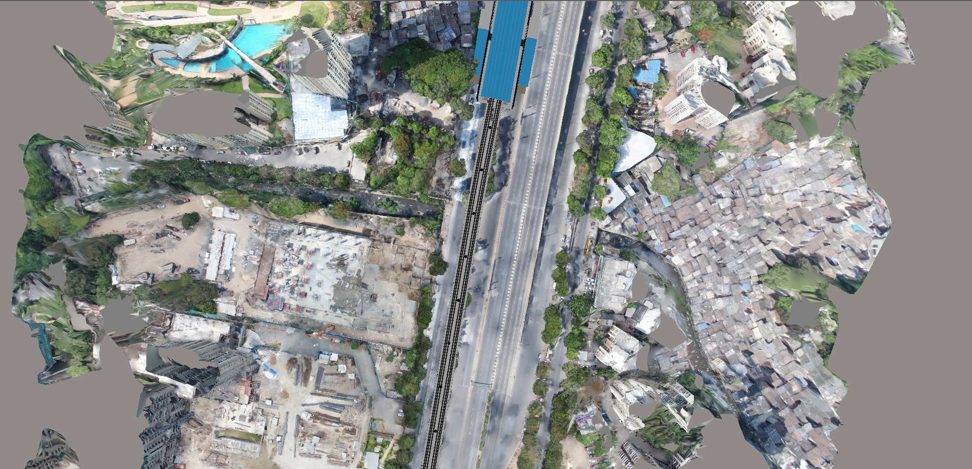
The outcome was improved visibility, stronger collaboration, and better decision-making across the project lifecycle.
Digital Twin Accelerates Metro Rail Approvals
Approvals are often delayed not because of disagreement, but because of uncertainty.
By providing stakeholders with a clearer understanding of corridor conditions and project impacts, Clove Technologies helped improve review efficiency and support more informed discussions.
The Digital Twin environment enabled stakeholders to evaluate information within a common context, reducing ambiguity and improving alignment during approval processes.
Outcome
- Improved approval readiness
- Reduced review complexity
- Faster stakeholder consensus
- Greater confidence in planning decisions
Reducing Infrastructure Risk Through Digital Twin Intelligence
One of the most significant benefits delivered by Clove Technologies was the ability to improve risk visibility before construction activities commenced.
The Digital Twin environment enabled project teams to evaluate potential issues earlier in the planning process, when mitigation options remained available and costs remained manageable.
This proactive approach reduced uncertainty and improved project predictability.
Outcome
- Lower risk exposure
- Improved planning confidence
- Reduced redesign requirements
- Better schedule protection
Improving Stakeholder Alignment Across Metro Infrastructure Programs
Infrastructure projects of this scale require collaboration across numerous organizations, each with unique priorities and responsibilities.
By creating a shared information environment, Clove Technologies enables stakeholders to work from a common understanding of project conditions and impacts.
This improved communication, accelerated discussions, and reduced time spent reconciling conflicting information.
Outcome
- Improved collaboration
- Faster decision cycles
- Reduced communication gaps
- Stronger stakeholder confidence
Strengthening Infrastructure Governance with Digital Twins
Effective governance depends on transparency and visibility.
The Digital Twin environment developed by Clove Technologies provides project leadership with improved access to information regarding project conditions, risks, assumptions, and dependencies.
This enabled stronger oversight and supported more accountable decision-making throughout the planning process.
Outcome
- Enhanced transparency
- Better executive oversight
- Improved accountability
- Stronger governance controls
Building Long-Term Infrastructure Asset Intelligence
The value delivered by Clove Technologies extends beyond planning and approvals.
The digital foundation established through the Digital Twin can continue supporting construction management, operations, maintenance, and future infrastructure expansion initiatives.
This ensures that digital investments continue generating value throughout the asset lifecycle.
Outcome
- Improved lifecycle visibility
- Better operational preparedness
- Support for future modernization initiatives
- Long-term infrastructure intelligence
Business Impact of Digital Twin Adoption
For leadership teams, the greatest value delivered by Clove Technologies was not technological.
It was strategic.
By improving visibility and reducing uncertainty, Clove Technologies enabled stakeholders to make better-informed decisions before major capital commitments were executed.
Project leadership gained:
- Greater decision certainty
- Faster stakeholder alignment
- Reduced project risk
- Improved capital efficiency
- Better governance outcomes
- Increased confidence in delivery plans
In an environment where uncertainty often drives cost and schedule impacts, visibility became a strategic advantage.
What Infrastructure Executives Can Learn from This Project
Visibility Is a Strategic Asset
Organizations that understand project conditions earlier are better positioned to manage risk.
Better Decisions Start with Better Information
A single source of truth improves both governance and execution.
Risk Should Be Managed Before Construction
The most cost-effective problems are those solved during planning.
Stakeholder Alignment Requires Shared Context
Decision-making accelerates when stakeholders operate from the same information environment.
Governance Improves with Transparency
Visibility strengthens accountability throughout the project lifecycle.
Digital Twins Are Decision Platforms
Their greatest value lies in improving outcomes, not simply creating models.
Infrastructure Intelligence Should Extend Beyond Delivery
Digital investments should continue supporting operations and asset management long after project completion.
The Future of Smart Infrastructure and Digital Twins
The future of infrastructure delivery will increasingly depend on decision intelligence.
As cities become more connected and infrastructure systems become more complex, organizations will require greater visibility across planning, construction, operations, and maintenance.
Digital Twins are rapidly evolving into strategic platforms that support predictive asset management, AI-enabled operations, infrastructure resilience planning, performance monitoring, sustainability initiatives, and capital investment optimization.
For transportation authorities and infrastructure owners, Digital Twins are becoming foundational capabilities for long-term infrastructure governance.

Why Digital Twins Matter for Future Infrastructure Programs
The Mumbai metro corridor initiative demonstrates how Clove Technologies helps infrastructure organizations reduce uncertainty before construction begins.
By integrating Digital Twin, GeoBIM, GIS, BIM, and Reality Capture workflows into a unified decision environment, Clove Technologies enabled stakeholders to improve visibility, strengthen governance, and make more informed planning decisions.
As infrastructure programs continue to grow in scale and complexity, organizations require more than engineering data alone.
They require connected infrastructure intelligence.
For metro rail authorities, transportation agencies, utilities, airports, and smart city programs, Digital Twins are increasingly becoming strategic decision platforms that help protect investments, improve project certainty, and accelerate delivery outcomes.
Ready to improve visibility across your infrastructure program? Explore Clove Technologies Technologies’ Digital Twin, GeoBIM, Scan-to-BIM, Reality Capture, and Smart Infrastructure solutions to build greater certainty into every project decision.